@The spacecraft conveys a camera system called the Mars Orbiter Camera (MOC) as well as the Mars Orbiter Laser Altimeter, the Thermal Emission Spectrometer, the Magnetometer/Electron Reflectometer etc. The shooting by MOC of the surface is planed to begin from mid-March 1998 and will continue up until the end of January 2000, ranging one Martian year.
@The MOC can acquire two kinds of CCD still images; one is wide, the
other narrow. The former produces colour images while the latter the R & IR
images. The images by the former "fish-eye" lens should be just like those
of weather photos of the Earth, and so very interesting to us. NASA is said
to release many of these images accessible by us on an Internet. The
specifications of MOC are as follows:
* Wide Angle: Optics:
11.3mm (f/6.5) with 140°, Resolution: 280-2km/pixel, Spectral
Response: 580nm(Red), 400-450nm(Blue)
* Narrow Angle: Optics:
3.5 m(f/10) with 0.4°, Resolution:1.4m/pixel Spectral Response
500 - 900nm
@Prior to the Surveyor arrival at Mars, the MGS/MOC first took a picture
on 02 July on the way, approximately 48 hrs before the Pathfinder landing.
Furthermore on 20 August still on its way it acquired pictures of the
gibbous planet. The images are accessible from the following web site:
http://mpfwww.jpl.nasa.gov/mgs/sci/images/img_current.html
@ Further information on the MGS project is given through the URL:
http://mpfwww.jpl.nasa.gov/mgs/index.html
*Note that any information about MGS is by PDT (Pacific Daylight Time). Add 7 hrs to get GMT.
@ The first image taken on 2 July shows the surface of (33.1°W, 19.4°N). A trace of the Valles Marineris dust originally found by the HST on 27 June is still visible. The image is however duller than the HST images: It is said that although the HST is 10 times farther from Mars than MGS, its image is sharper since the resolving power of the HST/WFPC2 is 15 times better than the MGS/MOC. However once the Surveyor is on the proper orbit at 400km above the surface, the MOC wide angle camera will obtain images at a resolution of 7.5km/pixel while the HST is best at about 20km/pixel.
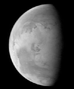
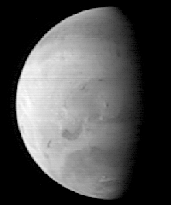
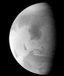
@Three pictures on 20 Aug (167°Ls) are on the Internet, as already mentioned in the OAA Mars Section corner.
The first was taken when MGS was 5.
67 million km from encounter and the sub-MGS point was (82.1°W, 23.6°N). The
surface was taken gibbous, and hence Solis L is still near the morning
terminator, and Mare Acidalium on the preceding side is still in the morning,
S Meridiani near the p limb. Valles Marineris looks still dusty and the
detail is interesting. Chasma Boreale is seen inside the npc.
The second
image was from 5.57 million km to Mars and the sub-MGS point was (217.4°W,
23.6°N) where Propontis I is the darkest evident, and interestingly the
Cerberus-Styx area is broadly shadowy. Elysium Mons casts a shadow showing
its extraordinary altitude. It is in this image that Korolev crater still
filled with the white ice is clearly seen. Olympia is evident; Rima Borealis
dark and broad.
The last one was from 5.51 million km apart and the centre
was aimed at (307.3°W, 23.6°N): Syrtis Mj is shown. The detail of Utopia is
outstanding though the contrast looks duller. Olympia is lighter somewhat
far from the terminator.
(Mk & Mn)