Up the Tenriugawa
(31 July through
I thought how I had pictured
it to myself before starting, and then
how little the facts
had fitted the fancy ……….Percival
I.
This is the first report of our
survey of the ways which Percival LOWELL took when he made a trip to the
. . . . . . . . Scanning, one
evening, in Tokyo, the map of Japan, in a vague, itinerary way, with the look
one first gives to the crowd of faces in a ballroom, my eye was caught by the pose
of a province that stood out in graphic mystery from the western coast. It made
a striking figure there, with its deep-bosomed bays and its bold headlands. Its
name, it appeared, was Noto.
He started from
Tokyo and went to Naoetsu (Naoyetsu)
facing to the Japan Sea via Nagano by train, and then by the use of three jinrikishas
(rickshaw: a small two-wheeled vehicle for carrying one passenger powered by a
man pulling) went along the seaside of the Japan Sea, and reached Anamizu (Anamidzu) inside Noto on 9 May, and made a return trip. He eventually took a
route down along the
The outward route
from
Why was the Harinoki Toge however at the season when still the higher
mountains were covered by heavy snow? We don’t know when he made this plan, but
the Harinoki Toge has been
very famous around the
We ought to have
taken warning from the general skepticism we met with at
The route
We had already lost three days; if we kept on, I foresaw the loss of more. It was very disheartening to
turn back, but it had to be done.
After his failure, his description becomes quite blunt or
silent about the route he took until he popped up again near the Saru-ga-Banba Toge far down in
Our objective point was now the descent of the Tenriugawa rapids. It was not the shortest way home, but it
was part of our projected itinerary and took us through a country typical of
the heart of
Then his route becomes very obvious:
II.
This summer the present writer made a trip by car along the
It was however impossible to go
along the Sakuma dam (built in 1956) because the road along the river was blocked
due to a landslide. I was therefore forced to take a roundabout mountain pass,
but we should say it was good to bypass the artificial part of the river and
when I could go down to the river again, the natural beauty of the gorge
re-appeared and the impression was not spoiled.
The
I started from
. . . . . . . .
.in front of us, came out the long outline of the Tokaido bridge, three quarters of a mile in length, like a
huge caterpillar crawling methodically across the river-bed. Gradually we drew
toward it, till its myriad legs glinted in the sunset glow; and then, as we
swept under, it wheeled round to become instantly a gaunt stalking silhouette
against the sky.
At the slightly upward town now
called
However we could not enter the area
of the Sakuma Dam because the road was closed, and was forced to take a long
detour to the mountain side, as stated before. The presence of the dam implies
some part of the Tenriugawa seen by
I then finally came to a place from
which we could overlook the river wholly and arrived at the Tokimata
port.
As to his boat going from Tokimata down to the Tenryu-Kyo,
While I was still standing gazing at lessening Tokimata, I heard a cry from behind me, and, turning, ducked
just in time to escape being unceremoniously somersaulted into the water by a
hawser stretched from bank to bank at a level singularly suited to such a
trick. The rope was the stationary half of a ferry to which I had neglected to
make timely obeisance. It marked, indeed, an incipient stage in the art of
suspension bridges, the ferryboat itself supporting a part of the weight, while
the ferryman pulled it and himself across. We met several more in the course of
the next few minutes, before which we all bowed down into the bottom of the
boat, while the hawser scraped, grumbling impotently, overhead.
Our boat was of
adaptive build. It was forty-five feet long, not quite four feet wide, and
somewhat over two feet deep. These proportions and the character of the wood
made it exceeding lithe, so that it bent like a willow before necessity. In the
stern stood the head man, wielding for rudder an oar half as long again as
those the others used. There was very little rowing
done, nor was there need; the current itself took us along at racing speed.
Shortly after
ducking under the last ferry rope we reached the gateway to the canon. Some
rapids made an introduction, rocks in places jutting out of the foam, and while
we were still curveting to the waves the hills suddenly closed in upon the
stream in two beetling cliffs, spanned surprisingly by a lofty cantalever bridge. An individual who chanced to cross at
the moment stopped in mid path to watch us through. The stream swept us in, and
the countryside contracted to a vanishing vista behind. We were launched on our
long canon voyage. The change was as sudden as a thunderstorm of a smiling
summer afternoon. It was an eclipse of the earth by the earth itself. Dark
rocks picketed with trees rose in still darker shadow on either hand, higher
than one could see. The black river swirled beside us, silent, sullen, swift.
At the bottom of that gorge untrodden by man, borne
by the dark flood that untouched by sunlight coiled snakelike along, we seemed
adventured on some unforgotten
For some time
we had voyaged thus with a feeling not unlike awe, when all at once there was a
bustle among the boatmen, and one of them went forward and stood up in the bow.
We swept round a corner, and saw our first great rapids three hundred yards
ahead. We could mark a dip in the stream, and then a tumbled mass of white
water, while a roar as of rage came out of the body of it. As we swept down
upon the spot, the man in the bow began beating the gunwale with his oar in
regularly repeated raps. The board gave out a hollow ring that strangely filled
the river chasm; a sound well calculated to terrify the evil spirits of the
spot. For indeed it was an exorcism of homoeopathic design. His incantation
finished, he stood motionless. So did the rest of us, waiting for the plunge.
The boat dipped by the bow, darted forward, and in a trice we were in the midst
of a deafening turmoil of boiling waters and crashing breakers. The breakers
laid violent hands upon us, grappling at the frail gunwale and coming in part
aboard, and then, as we slipped from their grasp, impotently flung their spray
in our faces, and with a growl dropped astern. The boat trembled like a leaf,
and was trembling yet, when, with nightmare speed, the thing had slipped into the
past, and we were shot out into the midst of the seething flood below.
Not the least
impressive part of the affair was the strange spirit-rapping on the bow. The
boatmen valiantly asserted that this was simply for signal to the man in the
stern. Undoubtedly now the action has largely cloaked itself in habit, but that
it once was superstitious is unquestionable. Devils still constitute far too
respected a portion of the community in peasant parts of
The steering
the boatmen did was clever, but the steering the stream managed of its own
motion was more so. For between the rapids proper were swirls and whirlpools
and races without end. The current took us in hand at the turns, sweeping us
down at speed straight for a rock on the opposite bank, and then, just as
shipwreck seemed inevitable, whisked us round upon the other tack. A thick
cushion of water had fended the boat off, so that to strike would have been as
impossible as it looked certain. And then at intervals came the roar of another
rapid, like a stirring refrain, with the boatman in the bow to beat the time.
So we swept on,
now through inky swirls of tide, now through snow-capped billows, moods these
of the passing stream, while above the grand character of the gorge remained
eternally the same.
Among his
photographs, a good photo of a wooden made bridge is found (cited in a Japanese
translation), but I suppose no such a fantastic bridge is there at present. At Tokimata, he wrote about the carp-cooking as follows, and I
hear it is also famous around here, but I had no time to make a survey.
I was left to
study the carp-pond, with its gold and silver fish, the pivot of attention of
the pretty little garden court which stood handy to the kitchen. This
juxtaposition was no accident; for such ponds are landscape and larder in one.
Between meals the fish are scenery; at the approach of the dinner hour they
turn into game. The inn guest having sufficiently enjoyed the gambols of future
repasts, picks out his dish to suit his taste or
capacity, and the fish is instantly netted and translated to the gridiron.
Next I planned
to go to Iijima where
When we reached
the reserved Hotel at Ina where the CMO members were to gather, it was already
dark, and eight hours passed since my start at
Next afternoon,
I tried alone to go down along the
The place where
. . . . .
. .a rumor became current that the road
had been washed away ahead, and that the basha would
have to stop some miles short of where we had hoped to be that night. This was disheartening. . . . . . ..
The rumor gathered substance as we advanced, until in consequence we
ceased to advance at all. At a certain village, called Miyada,
the basha drew up, and we were informed that it was
impossible to proceed further.
. . . . . . . . . . . . . . . . . . . . . .
The road ran along
the skirts of the mountains on the right, which fell in one long sweep to the
river, a breadth of plain unexpectedly gored by streams. The canons were
startlingly abrupt, and the darkness which now came on took nothing from the
effect. A sudden zigzag down to a depth of a hundred feet, a careful hitching
over a decrepit bridge, and a zigzag up the other side, and we were off at a
good trot again. This dispatch on the part of the men brought us in
much-improved spirits and in very good time into Iijima,
our hoped-for goal.
At Iijima, the town is slightly far from the
LOWELL’s “Down the Tenriugawa”
begins as follows:
We had made
arrangements overnight for a boat, not without difficulty, and in the morning
we started in kuruma for the point of embarkation. We
were eager to be off upon our voyage, else we should have strolled afoot down
the long meadow slope, such invitation lay in it, the dew sparkling on the
grass blades, the freshly tilled earth scenting the air, and the larks rising
like rockets up into the sky and bursting into song as they went. It seemed the
essence of spring, and we had a mile or more of it all before we reached the
brink of the canon. For even here the river had begun a gorge for itself
through the plain. We left our jinrikisha at the top and zigzagged on foot down
the steep descent, and straightway departed the upper life of fields and larks
and sunshine for a new and semi-subterranean one. It was not simply a change of
scene; it was a complete change of sphere. The world with its face open to the
day in a twinkling had ceased to be, and another world, a world of dark water
girt by shadowed walls of rock and trees, had taken its place.
Same afternoon
to evening, returning from Iijima, I ran up again to
Ina and further
Amusingly
. . . . . . .
..we under way once more, clattering down the main
street of the village. It was not only in the village that we made a stir. A basha is equal to the occasion anywhere. The whole
countryside stopped in its tracks to turn and stare as we passed, and at one
point we came in for a perfect ovation; for our passage and the noonday recess
of a school happening to coincide, the children, at that moment let loose,
instantly dashed after us pell-mell, in a mass, shouting. One or two of them
were so eager in the chase that they minded not where they went, and, tripping
over stones or ruts, fell headlong in the mud. The rest pursued us panting,
each according to his legs, and gave over at last only for want of wind.
As often noted, we held the CMO Meeting at
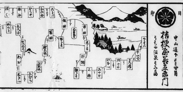
Ina: During the days of the Meeting, we visited once more the Kikyo-ya with all of the attendants (when we were given a woodblock print
of an old map around Simo-no-Suwa used in the Edo
Era), and also looked for the place where the Post Office was once built. It is
not far from the Kikyo-ya, and quite near the JR Shimo-Suwa
station.
We had started
somewhat late, stopped for the lack of umbrella, and now were committed to a
digression for letters I expected at Shimonosuwa. I
never order my letters to meet me on the line of march
but I bitterly repent having chosen that special spot. There is always some
excellent reason why it turns out most inconvenient.
From Shimo-Suma, we went up the Shiojiri Toge, and down to the Shiojiri Waki-Honjin in a reverse
direction with
The inn at Shiwojiri possessed a foreign table and chairs; a bit of
furnishing from which the freshness of surprise never wore off. What was even
less to be looked for, the son of the house was proficient in English, having
studied with a missionary in
Unfortunately, there is nothing to be related
with
After closing the CMO Meeting, I visited Uyeda Castle,
Zenko-ji Temple and so on as to which we report
in a following page.
(Masatsugu MINAMI, CMO Fukui)