CMO/OAA Cahier #06
Nix Olympica/Olympus
|
T |
HE Mars Map by Shiro
EBISAWA (published in 1954) looks similar to the well-known ANTONIADI Map
(published in 1930) but is said to be quite different in that the former compiles
several new markings as well as several deformations of the dark markings newly
known since the times of E M ANTONIADI. For example, the position of Nix Olympica in EBISAWA's is centred
about at (137°W, 23°N) while it was nearly at (128°W, 21°N) in the original
ANTONIADI Map. EBISAWA's value of Nix Olympica is based upon the photographic data taken by LYOT
and CAMICHEL in 1941, while ANTONIADI employed the value something old obtained
by SCHIAPARELLI in 1877 - 1890. (We should note however that ANTONIADI himself
secured the values (136°W, 21°N) and (132°W, 16°N) in 1911 and 1926
respectively. This clearly shows that the ANTONIADI topographic map was mostly
intended to incorporate not his
original findings but the foregoing
veterans' results. It should be remarked that the latter value by ANTONIADI is
not so different to the recent value by the US Geological Survey.
How about then the Tharsis ridges in EBISAWA's? Arsia Silva, Pavonis
L and Ascræus L are located at the different places
than in ANTONIADI's. If these correspond to the modern Montes: Arsia Mons, Pavonis Mons and Ascræus Mons
respectively, as far as we judge from the aspects in the topographic map
produced by the US Geological Survey, they should be centred at (120°W, 9°S),
at (113°W, 1°N) and at (104°W, 11°N) respectively, and these values are
apparently different to those in EBISAWA's classical
map. The position of the summit of Olympus Mons is also located near at (133°W,
18°N): This differs from the position in EBISAWA's.
Iuventæ Fons is an interesting point since it
is quite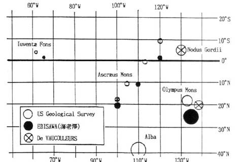 dark and tiny, and hence it once
selected as a standard site on the Martian surfaces to fix relatively other
markings (for example by DE VAUCOULEURS for the sake of the Viking flights).
The position of Iuventæ Fons was fixed by him based
on the photometric observation in 1941 and 1958 and can be checked in his
article entitled “A Low-Resolution
Photometric Map of Mars", Icarus
7 (1967) 310 to be (63°W, 5°S),
while US Geological Survey's result pins the marking down at (62°W, 4°N). [DE
VAUCOURLEURS' planning chart in 1971 (S&T May 1971) employs the value
(62°W, 5°N).] It should also be noted that the rather well-known name of Nodus Gordii is not identifiable
with a particular marking in Memnonia of the new map
by the US Geology Survey.
dark and tiny, and hence it once
selected as a standard site on the Martian surfaces to fix relatively other
markings (for example by DE VAUCOULEURS for the sake of the Viking flights).
The position of Iuventæ Fons was fixed by him based
on the photometric observation in 1941 and 1958 and can be checked in his
article entitled “A Low-Resolution
Photometric Map of Mars", Icarus
7 (1967) 310 to be (63°W, 5°S),
while US Geological Survey's result pins the marking down at (62°W, 4°N). [DE
VAUCOURLEURS' planning chart in 1971 (S&T May 1971) employs the value
(62°W, 5°N).] It should also be noted that the rather well-known name of Nodus Gordii is not identifiable
with a particular marking in Memnonia of the new map
by the US Geology Survey.
The Mars in the coming apparition will show the area of the Tharsis ridges
and Olympus Mons in a favourable moisturable season
and at the same time will pass nearly the sub-Earth point, and hence these
differences or confusions stated above should be kept in mind.
(Mn)
CMO #144 (25 April 1994) p1385
NB: The reason why the
measurements of the position of the volcano summit are often deviated from the
real position seems to be because of the misleading presence of a white roll cloud
which lies rather on the following flank. On the occasion of the opposition in
1997, Takashi NAKAJIMA (Nj) and the
present writer (Mn) had a good
opportunity to face to the CM transit of Olympus Mons on 18 March, and both
alternatively watched 20 times the moving of the Olympus Mons summit from 11:00
GMT to 11:47 GMT, and obtained the value Ω=135°W as the position of
Olympus Mons which was slightly larger than the value given by the US GS. As to
this observation, we recorded in the OAA Mars Section Report #10 in CMO #188
(10 April 1997) p2043. The following is an extraction:
“Olympus
On 17
March NAKAJIMA (Nj) and MINAMI (Mn) (at the Fukui City Observatory using a 20cm Refractor)
noticed Olympus Mons to be slowly passing the imaginary CM derived by the
presence of the bright npc, and hence they tried on
18 March the CM transit observations of Olympus Mons (just as a ceremony). They
began from 11:00 GMT (ω=127°W), just the opposition time, and made
alternately 20 times CMT timings up until 11:47 GMT (ω=139°W). As was
reported Olympus Mons was faint near the noon, and so Nj and Mn frequently made
use of a Green filter or Y48. The result was as follows: Olympus Mons was
"before" the CM until 11:23
GMT (ω=133°W) and "after"
the CM after 11:41 GMT. It looked to stay
or be passing the CM between 11:26 GMT (ω= 134°W) and 11:36 GMT
(ω=136°W). Nj and Mn hence concluded that the centre of
Olympus Mons was located at Ω=135°W. [According
to the result by the US Geological Survey, the centre of the volcano is at
Ω=133°W.] This was just a ceremony, but we should say it is very rare for us to come across the
case where Olympus Mons transits the CM in the presence of a bright small npc at opposition.”
See: http://www.kwasan.kyoto-u.ac.jp/~cmo/cmo/sec96/010/sec010.html
Back to the Index of the
Cahiers
Back to the CMO Home Page
/ Back to the CMO Façade