COMING 1996/97 MARS -- ( 6 ) --
Arctic Typhoon - M MINAMI (English)
* From the spring to the summer season in the Martian northern hemisphere to which we are facing, some Typhoons seem to occur sometimes near the perimeter of the north polar cap, as were observed by the continued mission of Viking Orbiter 1 (VO-1). The present introduction to the arctic cyclones is based on the article by Garry E HUNT and Philip B JAMES, Nature 278 (1979) 531.
Fig.1: Arctic cyclone revealed by Viking Orbiter 1
at 105 degrees Ls at (160 degrees W, 81 degrees N)
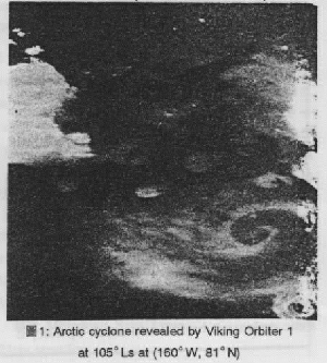
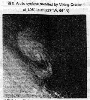
* VO-1 observed twice the cyclonic cloud formation, once at 105 degrees Ls, and then at 126 degrees Ls. The first cyclone was observed at (160 degrees E, 81 degrees N), and the second was at (227 degrees E,66 degrees N). The latitudes of the sub-solar point at those seasons were about 24 degrees N and 20 degrees N respectively, and hence the first typhoon was inside the area where the midnight sun was seen, and the second must have been near the boundary. The radii of the cyclones were about 100km and 300km respectively. It must be impossible to see such tiny(?) cyclones from the terrestrially based stations, but they may cause a blur to the north polar region, and hence it will be reasonable to remember the phenomenon.
Fig.2: Arctic cyclone revealed by Viking Orbiter 1
at 126 degrees Ls at (227 degrees W, 66 degrees N)
 * The VO performed the IR thermal mapping (IRTM) at five channels at 7, 9, 11, 15 and 20 micron, and those except for 15 micron characterise the ground temperatures with small differences caused by the presence of dust and condensates in the atmosphere, while the 15 micron temperatures T15 are characteristic of the atmosphere at an altitude 25km at a pressure of 0.6 hectopascal. Fortunately the first Typhoon was under the IRTM measurements inside the storm area as well as at the adjacent area to the north. It showed that a large temperature gradient existed except for T15: The rate of the gradient was about 0.2K/km, and the change was seen up to about 60km wide. The ground temperature thus inside the cyclone was ~ 230K, but at the area to the north it read 215K, and at the opposite side at the area to the south between 75 degrees N and 80 degrees N, the temperature gradually rose up to 237K. The temperature difference must have been characteristic of the disturbances produced by the front which separated the frigid arctic air from the warmer mid-latitude atmosphere. The fact that there was no gradient in T15 implied that the cloud disturbance was confined to the lower atmosphere.
* The observed temperatures were too high for the cloud to be composed of the dry ice. It is said the difference of temperatures in the 9 micron and 11 micron channels suggests the composition of the cloud, and the result showed that the spiral clouds were made of the water ice. Otherwise, the violet image more vividly showed the difference from the ground than through the red light. It was also known that at that season the water vapour content of the atmosphere is maximal over the north polar region (C B FARMER et al). It is however very plausible that the cyclonic cloud formation must also be enhanced by the presence of dust: the stirred dust will easily help the condensation of ice particles by the nucleation mechanism.
* HUNT and JAMES also discuss the meteorological structure of the cyclones theoretically, and evaluated the wind velocities and accelerations as well as vorticities, but here the discussion is omitted (just the wind velocity turned out to be 31.5m/s for the first storm). The results seem to be compatible with those suggested by Viking Lander 2.
* The second cloud showed its shadow (taken at 6:33 local time), and it gave an estimation of a height of 6-7km. If a linear lapse rate is applied to the first cloud, this seems to be located at the altitude of about 4km.
Coming 1996/97 Mars (6)
杒嬌抧偱偺镋晽
-- 撿丂惌 師
(Japanese)
亯....偙傟偐傜偺壩惎偺僔乕僘儞丄偮傑傝杒敿媴偺弔偐傜壞偵妡偗偰丄杒嬌椞堟偱塓姫偒镋晽偑婲偒傞傛偆偱偁傞丅偙傟偼償傽僀僉儞僌丒僆乕價僞乕堦錴(VO-1)偺寢壥偵傛傞傕偺偱丄偙偺偲偒偼堦夞栚105週s偲擇夞栚126週s偺擇夞偵傢偨傝塓姫偒塤偑嬌抧偵鎂應偝傟偰偄傞丅応強偼堦夞栚偺镋晽偺応崌(160逧丄81逳)偱丄擇夞栚偼(227逧丄66逳)偱婲偙偭偰偄傞丅sub-solar point偺堒搙偼偦傟偧傟 24逳丄20逳偖傜偄偱偁傞偐傜丄堦夞栚偺镋晽偼敀栭撪偱婲偙偭偰偄傞偑丄擇夞栚偼嫬栚偱偁傠偆丅殼偺傛偆偵尒帠側塓姫偒偱偁傞偑丄敿渓偼偦傟偧傟100km丄300km偖傜偄偺傛偆偱偁傞偐傜丄変乆偵偼栚棫偮傛偆側傕偺偱偼側偄偱偁傠偆丅偟偐偟杒嬌姤偺廃傝偺儃働偲偟偰丄偙偺庬偺尰徾偼懆偊傜傟傞壜擻惈偼偁傞丅
亯....偙傟傜偺徯夘偲暘愅偼Nature 278(1979)531偵偁傝丄Garry E HUNT (塸)偲Philip B JAMES (旤)偺幏昅偱偁傞丅
Fig.1: Arctic cyclone revealed by Viking Orbiter 1
at 105 degrees Ls at (160 degrees W, 81 degrees N)
亯....償傽僀僉儞僌偼戝焼傗抧昞偐傜偺擬鐃幩傪7丄9丄11丄15丄20兪m偺屲偮偺僠儍儞僱儖偱愒奜壏搙傪應傞偑(IRTM)丄偙偺偆偪15兪m埲奜偺僠儍儞僱儖偼昞柺壏搙傗偦傟偐傜偺戝焼偺恛傗嬅寢暔偵傛傞堘偄傪帵偡偺偵懳偟丄15兪m壏搙T15偼焼埑0.6透氖呓顿(25km忋嬻)偺戝焼傪摿挜晅偗傞丅岾偄堦夞栚偺镋晽偵偮偄偰偼偙傟傜偺壏搙偑丄僄儕傾撪偲偦偺杒偵偮偄偰暿乆偵應傜傟偰偄偰丄T15丂埲奜偵偮偄偰偼壏搙嵎偑弌偰偄傞丅偦偺壏搙孹幬偼乣0.2K/km偱丄斖埻偼60km偵媦傇(K偼愨懳壏搙偺偙偲丄K偺応崌偼邆饡t偗側偄偺偑姷廗)丅塓姫偒塤偺椞堟偱偼抧昞壏搙偑乣230K偩偑丄偦偺杒偱偼215K丄撿偺曽偼75邆m乣80逳偱彊乆偵忋偑傝237K偵払偟偰偄傞丅偙傟偼塓姫偒塤偑嬌姦偺杒嬌抧偺戝焼偲抔偐偄拞堒搙偺戝焼傪暘偐偮慜慄偵傛偭偰惗偠偨傕偺偱偁傞偲埫帵偡傞丅傑偨T15偵澨壔偑側偐偭偨偙偲偐傜丄壏搙岡攝偼崅搙偺掅偄戝焼偵尷傜傟偰偄傞偲峫偊傜傟偰偄傞丅
Fig.2: Arctic cyclone revealed by Viking Orbiter 1
at 126 degrees Ls at (227 degrees W, 66 degrees N)
丂亯....鎂應偝傟偨壏搙偺崅偝(抔偐偄)偐傜丄塓姫偒塤偑擇巁壔扽慺偱弌樢偰偄傞偲偼峫偊傜傟側偄丅 9兪m偲11兪m僠儍儞僱儖偱偺壏搙嵎偼塤偺惉暘偲娭學偡傞傜偟偄偑(偦偆偄偆榑暥偑偁傞)丄偙傟偱尒傞偲丄塤偼悈偺昘偱弌樢偰偄傞傛偆偱偁傞丅懠偵丄僼傿儖僞乕偱摟偐偟偰丄愒怓岝傛傝傕惵怓岝偱抧柺偲偺嵎偑傛傝慛柧偱偁傞丄偮傑傝惵怓岝偱岲偔弌偰偄傞偲偄偆偙偲偑偁傞丄摍偱偁傞丅傕偆堦偮丄偙傟偼壗張偐偱傕怗傟偨偑丄偙偺帪婫丄杒嬌姤绮傝偱悈忲焼検偑嵟戝偵側傞偲偄偆寢壥偑丄偙偺崰幄昞偝傟偰偄傞偺偱偁傞丅
亯....扐偟丄塤偵恛偑崿偠偭偰偄傞偙偲偼壜擻惈偑偁傞丅摿偵丄椻媝偵傛傞悈忲焼偺嬅寢偺嵺偵恛偑妀偵側偭偰偄傞偙偲偼娫堘偄側偄偲偝傟傞丅
丂亯....偙偺HUNT-JAMES偺榑峫偱偼丄塤偺撪晹偺焼徾揑峔憿偵偮偄偰傕榑偠傜傟丄晽懍側偳傕昡壙偝傟偰偄傞偑偙偙偱偼偦偺榑弎偼棯偡(30m/s偖傜偄偱偁傞乯丅寢壥偼償傽僀僉儞丒儔儞僟乕擇錴(VL-2)偱偺寢壥偲崌偭偰偄傞傛偆偱偁傞丅亯....擇夞栚偺塤偵偼塭偑塮偭偰偄傞條偱偁傞(屵慜俇帪敿)丅偙傟偐傜崅偝偼6乣7km偲弌傞傛偆偱偁傞乮晛捠偺塤偱嵟崅崅偝50km偖傜偄偼抦傜傟偰偄傞)丅 偙傟傪彅忦審偐傜堦夞栚偺塤偵摉偰浧傔傞偲崅偝4km偲弌傞桼偱偁傞丅
10 Years Ago (14)
--- CMO #026(10 Feb 1987) (Japanese)
1987擭偵側偭偰壩惎偼擔杤帪偵偼撿拞傪夁偓偰惣偵孹偄偰偄傞傛偆偵側偭偨丅乽偆偍嵗乿傪杒忋拞偱丄愒堒偼侾寧弶傔偵偼杒偵側偭偰栭敿偺惣嬻偵巆傝丄杤偼23帪抧曽帪崰偩偭偨丅娤應帪娫偼梉曽偐傜悢帪娫偩偗偵側偭偨偑丄擔杮偱偺撿巵丄戜杒偱偺挘楉夃巵偺儖乕僠儞娤應偼懕偄偰偄偨丅侾寧屻敿偵偼帇捈宎偼俇昩戜偵彫偝偔側傝丄 Ls偼320邞鋫蓚葌羵絹B
丂OAA Mars Section偵婑偣傜傟偨丄偙偺婜娫偲捛壛偺曬崘偼丄撿惌師巵丄挘楉夃巵丄拞搰岶巵丄徏杮捈栱巵偺彅巵偐傜偩偗偵側偭偨丅娾嶈揙巵偼侾寧偺忋弡偱崱婜偺娤應傪廔椆偟偰偄傞丅娾嶈巵偺僗働僢僠悢偼俀俇俀枃偵払偟偨丅
丂偙偺婜娫偵偼M Tyrrhenum偐傜Syrtis Mj晅嬤偑尒偊傞帪婜偩偭偨偑丄嵟憗徻嵶傪懆偊傞偙偲偼擄偟偔側偭偰偟傑偭偰偄偨丅撿嬌傗杒墢偺柧傞偝傕娤應偝傟偰偄傞偑丄徻嵶傪媍榑偡傞抜奒偱側偔丄師婜偺娤應偺栚昗偲偟偰丄婰壇偝傟偨偄偲婰偝傟偰偄傞丅
丂婰帠偲偟偰偼丄徖郪栁旤巵偵傛傞乽榝惎幨恀偺幚嵺(9) C-8, Canon T-90, H2-TP 偲嶰怓暘夝乿偑宖嵹偝傟偨丅婰帠偵傛傞偲丄徖郪巵偼1983擭崰傛傝悈慺僈僗憹姶張棟僐僟僢僋僥僋僯僇儖僶儞僼傿儖儉偵傛傞揤懱幨恀傪帋偝傟偰偄偨偲偺帠偱丄19俉6擭偵偼僼傿儖僞乕偱 B,G,R偺嶰怓偵暘夝嶣塭偟偨僥僋僯僇儖僷儞僼傿儖儉偐傜丄僇儔乕儕僶乕僒儖僼傿儖儉偵崌惉偡傞壩惎僇儔乕幨恀偵挧愴偝傟偨丅嶣塭偵巊梡偟偨僼傿儖僞乕丄儕僶乕僒儖僇儔乕僼僀儖儉側偳嶣塭帒嵽偲僥僋僯僢僋傪惿偟偘傕側偔斺鄉偝傟偨丅嶌椺偼乽揤暥擭娪乿1987擭斉偺僩僢僾儁乕僕偵尒傞偙偲偑弌棃傞丅愺揷惓巵偼乽榝惎幨恀偺嶣塭偵偮偄偰偺傾儞働乕僩乿夞摎偺廤寁寢壥偺戞俀夞傪揨傔偰敪昞偝傟偨丅乽曋傝乿偵偼丄愺揷惓巵埗偺僪儞丒僷乕僇乕巵偐傜偺棃怣偑嵹偭偰偄傞丅偄傛偄傛屼戝偺搊応偱偁傞丅
(Mk) 懞忋徆屓
 CMO #184